


From the brand


6-36 Months | Infant & Toddler

3-5 Years | Pre-School

5+ Years | School-Age

i-Poster Series

Connectrix & Book Serise


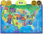
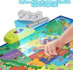
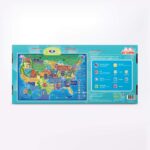
MULTI AWARDS WINNING FUN LEARNING TOY – Family Choice, Mom’s Choice Gold Metal & Tillywig Brain Child Award Winner! Creative Child Seal of Excellence Award Winner! The most popular interactive touch activated talking USA map for kids.
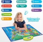
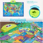
QUALITY IMPROVEMENT – by adding a fabric frame for higher quality; Hang on a wall; Play on the floor or use as a colorful play mat.
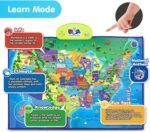
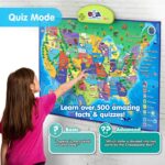
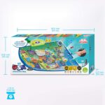
EXPLORE the USA – Learn basic information, climate, general knowledge and fun facts about the 50 States with over 500 facts about all the States.
BEST CHRISTMAS GIFT IDEA – Our interactive toys are filled with educational values to develop skills such as music, concentration, earth science, memory, problem solving, geography and environment.
ENGAGING, FUN & RISK-FREE – requires 3 AAA batteries that are included; Intended for Preschoolers and early learners of ages 5 and up.
Customers say
Customers find the interactive map educational and fun for children, with lots of information packed in and various interactive activities. They appreciate its ease of use, particularly for young children, and consider it a great learning gift. The functionality and quality receive mixed reviews – while some say it works well, others report issues with certain areas not working, and while some find it well-made, others describe it as cheaply made. The country information aspect also gets mixed feedback, with customers loving exploring facts about each country but noting missing information for some regions.
AI-generated from the text of customer reviews


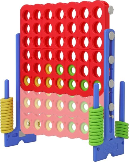
 for Kids & Adults, Indoor/Outdoor Connect Game with Quick-Release Slider, Perfect for Family and Party Games")
Heather Hill –
Excellent Honeschool Resource!
This is one of my children’s most favorite tool to use during school and even when we aren’t homeschooling. We have had it for over 2 years and it is in great shape even after traveling with us. It folds up great and has taken a beating and continues to provide my boys with hours of education and entertainment.
It has multiple modes that allows them to explore all different parts of the world including but not limited to: flags, languages, geography, capitals and country finds, and landmarks.
I hightly recommend this product for anyone looking to have fun learning and exploring the world.
Rakkar –
Loved !
Great map . Interactive . Son loves it !
Amazon Customer –
Fun Learning Tool
I bought this as a 7th birthday gift for my great nephew who is a geography buff & he loves it!
jay –
A good investment but be ready to accept few down points.
This product is really good.
-> I loved the way, they gave different selection tabs for capital and country, landmarks, flags, population, fun facts.
-> Even these options have, info mode and ? Mode.
-> I am thankful for the volume up and down buttons.
-> It would be even nicer, if we had a tab that said national bird, animals or emblem. Idid not try the fun facts tab yet, so i do not know, if they are listed there.
But! It does have some things that left me wishing for more:
1. There are some countries(named in white) that the map does not give any info about. I wish they could do all the countries and oceans too. Since the world has both continents and oceans.
2. There is an ocean missing. Southern ocean. The reason might be that the space has been covered by all the flags. Still the southern ocean should be mentioned, as the map acts as a direct/indirect teaching tool. Leaving out one of the oceans is giving half knowledge. Half knowledge is dangerous.
3. It would be nice, if they had given a sturdy support width wise, as a strip right under the electronic controls(green part). Map keeps drooping at the ends of the green control box(I have the âMy Bodyâ poster, which is not so wide, but started tearing at the ends of itâs yellow control box). That is the reason why, i pasted the world map, using painterâs tape. To distribute the weight and stop the map from drooping. I removed one star for this point (and the missing ocean).
Listed are the changes recommended for the manufacturer and also notes for customers, so they know what to expect.
Good luck.
Amazon Customer –
Educational toy
My grandsons love it!!! It encouraged them to explore/learn more/ do I love it ! Thanks for making this educational toy available !
Catherine Agudelo Sarmiento –
Greatðð
Love itðð
Amoy –
It is too flimsy
The chart is too flimsy. Not substantial enough. However, the knowledge to be gained is good
R. Poppy –
Well Received by Grands
Bought for nephews. They use it and really enjoy the quizzes.
E F –
After taking a road trip to Florida, my kids are absolutely fascinated with the US. This interactive map has quickly become one of their favourite things to play with, helping them learn more about the states. It’s a pretty neat supplementary resource for teaching US geography.
Carmen Cantalejo diaz –
Es súper chulo o por sea ponerlo en el aula, funciona muy bien
Cliente Amazon –
Un gioco comprato per mio figlio di quattro anni e mezzo ma che e’ divenuto il passatempo per tutta la famiglia. Molto divertente, facile da usare e con un inglese molto chiaro e comprensibile.
Suchi –
Got it for my son bday gift n he just loved it .. Thank you so much ..ð
Bertha C. –
El mapa interactivo no tiene el idioma español, solo viene en Inglés y los niños ni caso le hacen, pues no entienden